Photograph of the train approaching the section house at Alta Lake on the Pacific Great Eastern Railway. Denis DeBeck's house is also seen in the photo. The handwriting on the verso reads: "Alta Lake train arriving from Lillooet, house was the forester, was DeBeck, section house steps."
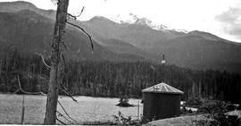
Photograph of the water tank used by the Pacific Great Eastern Railway trains at Alta Lake station on Alta Lake. Whistler Mountain is in the background..
Book of blue cheque stubs belonging to a member of the Jardine-Neiland or Betts family. The cheque stubs are dated from July 25, 1939 to October 26, 1939. The payees include [BC Call-Loon Co.], Angus Gorrie, Mrs. J. Craddock, Mrs. L. Neiland, and the Pacific Great Eastern Railway.
File contains letters from Cliff Fenner, one to the Chief Forester of B.C. Forest Service and two to The Director of Parks Branch regarding Garibaldi Park. The first letter is about the naming of Haney area in regard to what should be included in Garibaldi Park. The second letter discusses the helicopter tour to evaluate Garibaldi's Olympic Games potential. The last letter discusses the potential for the Olympic Games in the Cheakamus Lake area. This letter has a paper attached detailing measurements, such as snow depth, from March 19, 1960.
A frame with four photographs spliced together to create a panoramic shot of Alta Lake and the surrounding mountains, including a part of the Pacific Great Eastern railway track on one side.
A surveyor's plan for part of the Whistler Cay neighbourhood that shows how the lots will be subdivided. The only named landmarks are the Pacific Great Eastern Railway, Lorimer Road, Alta Lake and Alta Creek. The scale is 1 inch = 100 feet. The bottom left hand corner contains a legend and signatures from approving officers at the Department of Highways, the owners of the land, and the surveyor. Written just above this in red pen is C. Mott.